


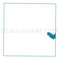
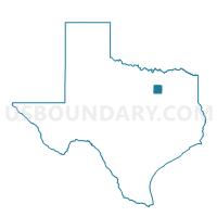
Voting District 2330, Dallas County, Texas
About
Outline

Summary
| Unique Area Identifier | 672226 |
| Name | Voting District 2330 |
| County | Dallas County |
| State | Texas |
| Area (square miles) | 11.03 |
| Land Area (square miles) | 10.97 |
| Water Area (square miles) | 0.06 |
| % of Land Area | 99.46 |
| % of Water Area | 0.54 |
| Latitude of the Internal Point | 32.72566350 |
| Longtitude of the Internal Point | -96.55898810 |
Maps

Graphs
Select a template below for downloading or customizing gragh for Voting District 2330, Dallas County, Texas


Neighbors
Neighoring Voting District (by Name) Neighboring Voting District on the Map
- Voting District 0029, Kaufman County, TX
- Voting District 0037, Kaufman County, TX
- Voting District 2324, Dallas County, TX
- Voting District 2325, Dallas County, TX
- Voting District 2326, Dallas County, TX
- Voting District 2328, Dallas County, TX
- Voting District 2329, Dallas County, TX
- Voting District 2331, Dallas County, TX
- Voting District 3337, Dallas County, TX
- Voting District 3339, Dallas County, TX
- Voting District 3403, Dallas County, TX
- Voting District 3406, Dallas County, TX
- Voting District 3409, Dallas County, TX
- Voting District 3900, Dallas County, TX
- Voting District 3902, Dallas County, TX
Top 10 Neighboring County Subdivision (by Population) Neighboring County Subdivision on the Map
Top 10 Neighboring Place (by Population) Neighboring Place on the Map
- Dallas city, TX (1,197,816)
- Mesquite city, TX (139,824)
- Balch Springs city, TX (23,728)
- Seagoville city, TX (14,835)
Top 10 Neighboring Unified School District (by Population) Neighboring Unified School District on the Map
Top 10 Neighboring State Legislative District Lower Chamber (by Population) Neighboring State Legislative District Lower Chamber on the Map
- State House District 4, TX (181,882)
- State House District 101, TX (163,601)
- State House District 110, TX (150,703)
Top 10 Neighboring State Legislative District Upper Chamber (by Population) Neighboring State Legislative District Upper Chamber on the Map
Top 10 Neighboring 111th Congressional District (by Population) Neighboring 111th Congressional District on the Map
Top 10 Neighboring Census Tract (by Population) Neighboring Census Tract on the Map
- Census Tract 173.05, Dallas County, TX (9,583)
- Census Tract 170.03, Dallas County, TX (9,567)
- Census Tract 173.04, Dallas County, TX (9,322)
- Census Tract 172.02, Dallas County, TX (8,477)
- Census Tract 173.03, Dallas County, TX (7,795)
- Census Tract 173.06, Dallas County, TX (7,635)
- Census Tract 502.01, Kaufman County, TX (6,395)
- Census Tract 173.01, Dallas County, TX (6,158)
- Census Tract 174, Dallas County, TX (5,319)
- Census Tract 171.01, Dallas County, TX (5,144)
Top 10 Neighboring 5-Digit ZIP Code Tabulation Area (by Population) Neighboring 5-Digit ZIP Code Tabulation Area on the Map
- 75149, TX (56,065)
- 75126, TX (33,396)
- 75181, TX (25,908)
- 75180, TX (23,031)
- 75253, TX (18,450)
- 75159, TX (18,339)